

Hawai‘i-Futures Codex:
Design Studio
Curriculum
Supplement
Connelly, Sean. (2010) HAWAI‘I-FUTURES Interventions for Island Urbanism.
New Media, After Oceanic. www.hawaii-futures.com.
CONTENTS
I. Introduction
II. Islands’ Vision: Moku, Ahupua‘a
III. Introducing Agromilitourization
IV. Film. O‘ahu Military Atlas 1898-2020
V. Nonlinear Waikīkī
VI. Billion Dollary Streams
VII. Conclusion (Hawai‘i Nonlinear)
Like a tree, a culture is forever growing new branches, foliage, and roots. No culture is ever static and can be preserved like a stuffed gorilla in a museum.
Albert Wendt, in Towards a New Oceania
To exist, humanly, is to name the world, to change it. Once named, the world in its turn reappears to the namers as a problem and requires of them a new naming. Paulo Freire, in Pedagogy of the Oppressed
I.
Introduction
Hawai‘i-Futures champions 'Āina as a proactive measure to enhance wellbeing in our built environment. As a public art project, Hawai‘i-Futures presents an introduction for innovative concepts that propel the discourse of 'Āina as both a built environment and a living system of sustenance, forward. The term “recovery,” to describe 'Āina work, is used over the term “restoration” to express a nuanced understanding of the process not as a return to the past but as a contemporary futurist process of reclaiming lost, stolen, erased, corrupted, or destroyed land, water, and other island resources essential to the native bioculture. “Agromilitourization,” a term coined by the artist for Hawai‘i Futures, is a portmanteau of agriculture, “militourism”—a concept by Teresia Teaiwa describing her initial encounter with Honolulu—and urbanization, used to identify the specific forces shaping the built environment of the Hawaiian Islands in promotion of US urbanism—a dynamic system of settler colonialism that continues to impose ecological devastation upon the occupied Native territories of the United States while perpetuating racial injustices against Native people.
Metrics
Since it’s humble launch in 2010, Hawai‘i-Futures has accumulated global influence in thinking about the built environment through the lens Hawai‘i, and has been utilized in various curriculum in educational institutions both in Hawai‘i and nationally, most notably in graduate programs of architecture, landscape architecture, and planning at Harvard University, Massachusetts Institute of Technology (MIT), Columbia University, and the University of Hawai‘i at Mānoa, emphasizing the global relevance of the future wellbeing of built environments in Hawai‘i, the Pacific, and beyond.
Connelly's Hawaii Futures project utilizes new media, motion graphics, and projection models to promote the resurgence of Hawaii's native built environment, supporting Indigenous concepts. The project started as an open-source web-based installation in 2010 and grew into a groundbreaking architecture design and community studio. The work a engages satellite-accurate modeling of an urbanized land division to highlight the interconnectedness of Hawai‘i ecosystem, culture, and community. Connelly's approach offers a unique perspective and platform for interdisciplinary collaboration and advocacy, promoting positive change through the use of new media and social practice. Hawai‘i Futures demonstrates the potential of these tools to promote sustainable preservation and revitalization of the native built environment in Hawaii and bridges the gaps between Indigenous knowledge and the digital realm.
Artist Statement
"LUCKY WE LIVE HAWAI‘I" is a common phrase amongst locals, encapsulating a profound appreciation for our islands' natural beauty, community, food, and lifestyle. Despite its challenges, life in Hawai‘i provokes deep respect for the islands and a commitment to their protection and perpetuation.
While physically isolated, Hawai‘i is intrinsically linked to the world, with a wealth of unique biodiversity and an untapped potential for clean energy. Yet, the mass-marketed image of Hawai‘i as an idyllic paradise masks severe environmental degradation. This degradation, stemming from deforestation, urban sprawl, pollution, and climate change, threatens the socio-cultural, political-economic, and ecological fabric of Hawai‘i.
Hawai‘i Futures, inspired by traditional Hawaiian resource management, aims to challenge and reshape these realities. We propose a more holistic, place-based perspective of Hawai‘i’s built environment. We want to ignite discussions about how architecture, landscape, and urban design can create resilient, community-focused places to live.
We encourage you to ponder the following questions:
How would public access to streams for recreation, education, and agriculture transform land use paradigms?
How would neighborhoods change if every resident was within a short walk of a farmers market selling locally grown foods?
How would the urban layout transform if every home had access to a common agricultural area?
How would urban development patterns shift if utilities were decentralized, with rainwater harvested in valleys and solar power generated along the coast?
How would development change if there was a maximum developable footprint within each watershed?
How will we adapt to the inevitable occurrence of sea level rise and erosion?
We present these questions in a solution-oriented format, illustrating a transformational vision for restoring ecosystems and reorganizing Hawai'i’s developed lands over the next century. This extended timeframe acknowledges the multi-generational effort this level of urban reorganization will require.
The future resilience and abundance of Hawai'i depend on how well we integrate our socio-cultural and political-economic systems to complement each watershed's ecological cycles. Our built environment shapes our attitudes, lifestyles, and our abilities to create culture and perpetuate the values that make Hawai'i unique.
The choices we make in designing Hawai'i's built environment today will shape the culture future generations inherit tomorrow.
Thank you for your attention and time—
Sean Connelly
Studio Curriculum Supplements
II.
Islands’ Vision
Moku, Ahupua‘a
Across the depths of time Ma‘ilikūkahi arose as an enlightened chief who breathed a legacy that would endure in time, for generations. A testament to the Native democracy of Hawai‘i’s early days, echoes of Ma‘ilikūkahi still resonate today, carried in the stories that recall times of tumultuous hardship, when O‘ahu’s biocultural resource management system had faltered island-wide, lost amidst confused and unclear boundaries the election of
Ma‘ilikūkahi sought to resolve
. Across oral histories, Ma‘ilikūkahi emerged as a beacon of humanity and peace, and clarified the moku system with frameworks of corresponding ahupua‘a, ‘aina, and a civic era of peace for O‘ahu, gem of the seas.
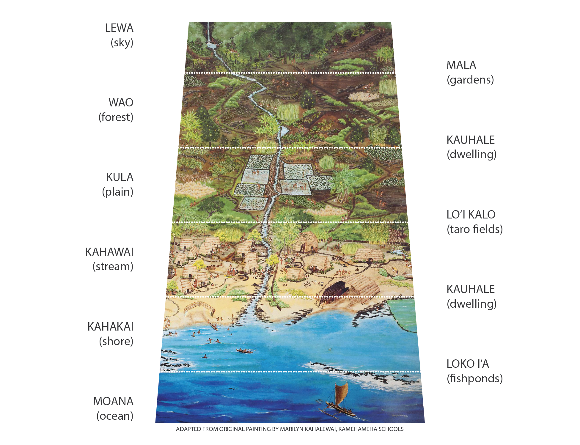
Boundaries with divine purpose, the land, once fractured and disjointed, was made whole again through the unity of humble yet mighty units: moku, ahupua‘a, ‘ili, and their myriad variations. Within this intricate tapestry, the mantle of civic responsibility fell upon the shoulders of both citizens and chiefs. Side by side, toiling, nurturing the land and guiding its natural and artificial elements in a culture of care. Between sky, mountain, and sea, combined efforts, bountiful nutrients entwined with stewardship, ceremoniously embodied the heartbeat of the island, weaving sustenance, reciprocity, and responsibility into the very fabric of daily life.
Native Hawaiians have, since time immemorial, devised and engineered island economies in a holistic ecological context, creating a system that perceives and integrates other systems. This recursive process, a cycle of observation and interaction spanning various ecological strata—from saline environments to freshwater ecosystems—has facilitated the growth and increased the island's capacity to sustain life. This is reflected in the concept of ‘Āina, or that which feeds.
The capacity of each island's economy is meticulously managed, quantified, and tracked in the cultural production of knowledge, dance, song, place names, and other mnemonic strategies accounting for observing an array of active resources such as water, soil, and even collective consciousness. These resource volumes shape the continuous expanses of land, sea, and sky into productive units of technology-infused data, information, and guidance perceiving a complete science of the environment that permeates every level of daily life.
The traditional moku system, rooted in Hawaiian culture, ensured equitable distribution of resources across Pae 'Āina Hawai‘i, the Hawaiian Islands. This system encompassed varying levels of division, from moku (districts), ahupua'a (divisions), and 'ili (sections), to kuleana (responsibilities) and beyond. Within the moku, ahupua'a represent unique land divisions, each taking diverse forms as dictated by the landscape. These divisions may be wide or long, small or large, landlocked, enclaved, adjacent, or scattered.
Each ahupua'a's boundaries are shaped by a variety of factors that span across numerous locations. These can be hydrological (pertaining to water allocation), geological (soil and material composition), political (burial sites and status), genealogical (lineage and cosmic continuity), and biocultural (collective memory and learning). The concepts of moku, ahupua'a, ‘ili, and kuleana are pivotal as they provide a scale for maintaining the constant vigilance required to care for the resources that flow within and around Hawai‘i Nei.
Listen & Remember
“Ahupua‘a are among the largest moving structures on Earth with surfaces emerging from the genealogy of the planet itself, infinite and universal. When used as an ecotechnology, the massive, watery, and viscous architecture of ahupua‘a directs space to operate with planetary magnitude.”
1. Motion axonometric of O'ahu showing moku system by moku, ahupua'a, and 'ili.
2. Typological approach to ahupua'a diagrammed architecturally.
3. Three landscape prototypes for ahupua'a cultivation.
4.An section line through Hawai‘i and O‘ahu compares elevation by geological age.

“Ahupua‘a Are Not Ancient.
They Are Oppressed Systems In Recovery.”
They Are Oppressed Systems In Recovery.”
-Value of Hawai‘i, 3.
Studio Curriculum Supplements
III.
Introducing Agromilitourization
Where did the ahupua‘a go? They are still present but drastically transformed. To understand this transformation as a novel example of unprecedented physical change to the Hawaiian Islands and it’s environmental degradation, Hawai‘i Futures introduces our special word coined to describe the unique conditions of the built environment of the United States in Hawai‘i, and the coalescing force of agriculture, military, and tourism that feeds the urbanization of US built environments, or US Urbanism. To describe the unique formation and process that results—the artist coins a novel term to describe the experience of today‘s oceanic built environment as agromilitourization, a portmanteau of the word agriculture; the word militourism, coined by Teresia Teaiwa to describe their first experience of Honolulu; and the word urbanization, the process of making an area more urban.
AGRO-MILI-TOURI-ZATION:
IV: Film. O‘ahu Military Atlas, 1898-2020
Sean Connelly (2021)New research on Hawai‘i’s built environment and its transformations over time underscores the importance of land use as a key determinant of environmental health and social justice. In particular, zoning regulations, the legal tool used by US state governments to dictate land use, wield a significant influence. Indeed, zoning regulations, a legal instrument conferred upon US state governments through the principles of federalism, are instrumental in shaping land use. This aspect of police power, intended to safeguard public health and safety, has a profound impact on our built environments. These regulations and the institutions they empower become embedded in the infrastructure of our built environments, and determine the patterns of daily life, in turn, the health and wellbeing of communities.
Our understanding of land use and zoning in Hawai‘i provides a roadmap to unravel the complex history of our built environment. It also illuminates the potential paths towards a more sustainable future. This understanding is crucial for practitioners of the built environment like artists, architects, planners, urban designers, and scholars, who bear the responsibility of reshaping our built environments to promote equity and health.
The dominant model of urbanism in the United States is a far cry from the native Hawaiian approach to land use. This model, characterized by single-use zoning, imposes an inflexible pattern on Native lands that disrupts the biocultural flow of vital resources. In contrast, the ahupua‘a system, an indigenous Hawaiian method of land division, is attuned to the rhythms of the natural world. The Native system, however, has been suppressed and distorted by over a century of foreign influence, most notably the US military and the American zoning maintaining its presence in Hawai‘i.
The pervasive military influence on the Hawaiian Islands, driven by a history of American-led infrastructure projects, has wrought significant damage to our environment, culture, and food security. The cumulative historical footprint of the US military on O‘ahu uncovers a troubling narrative of land use zoning tailored to reinforce military needs over those of Native and Local people. This is strikingly evident when comparing the functional land use plan of the US military—encompassing housing, training, and communication—established pre-statehood, against the state-designated land use districts—urban, agriculture, conservation—established post-statehood.

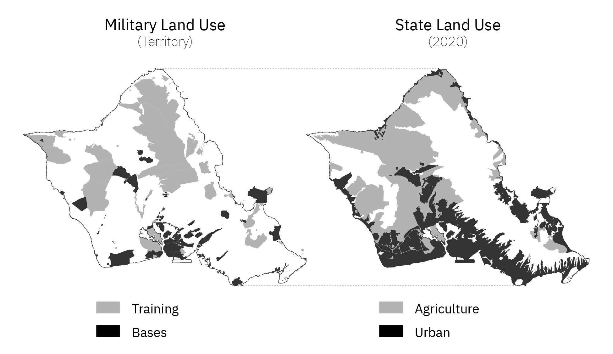
The interlocking relationship of US military and American urbanism on Oʻahu (Courtsey the Artist).
The revealing pattern shows land surrounding military training areas zoned for agriculture or conservation, while urban zoning was assigned to areas adjacent to military bases. This programmatic adjacency that exists between US Military and State land use districts has often been overlooked with severe implications for its communities. Notably, this is evident in the stark ten-year difference in life expectancy between communities in agricultural land use districts that are adjacent to military training areas compared to populations in urban zones next to military commercial bases and housing, with longer life expectancies than the former. These disparities are a glaring indictment of the existing model of American urbanism—underscoring the profound human cost of such urban-military prioritization maintained as the structure of land use in Hawai‘i to this day, currently.
The US military‘s establishment has a complicated history marked by disregard for Native rights. This continuous disregard began as far back as the violation of the Royal Proclamation Line of 1763, a formally acknowledged diplomatic boundary meant to protect Native territories, and which was designed to follow the geological hydrological divide of the East Coast of North America Turtle Island. But instead there is ongoing genocide. The expansionist tendencies of the early American colonists brought them into conflict with this boundary, highlighting the fraught relationship between the US military and Native communities. The military is born to be anti-moku, anti-ahupua‘a, ant-ʻāina.
For instance, O'ahu, often overlooked as a case study in urbanism, is more than just the capital city of Honolulu. It is a militarized hub from which the US Indo-Pacific Command exercises control over a large portion of the Earth's surface. Yet, this reality is often obscured by the idyllic images of Hawaii's natural beauty that dominate the tourism industry. Each island narrates a unique struggle: biochemicals, fuel, bombing, water, sacred sites, and more. The US military's alterations of the Hawaiian Islands have had profound consequences. The filling in of fishponds, dredging of fertile reefs, banning of language, and bombing of mountaintops have disrupted the islands' ecosystems and continue to impact the health and quality of life of residents and visitors. The destruction of environmental integrity, cultural heritage, and food security is a testament to the harmful effects of these infrastructural impositions.
In our quest for a more equitable and sustainable future, we must acknowledge and learn from the past. The ahupua'a system, though suppressed, remains a beacon of resilience and a blueprint for a land use model that respects the natural world and prioritizes the wellbeing of communities. The following graphics illustrate a few of the major outcomes that are prevalent in places around Hawai‘i built environments in conflict with US Urbanism, such as fragmented governance, broken stream, separation of food and daily life, land crimes, food insecurity, loss of fertile soil, climate, sea level rise, erosion, and the total developed footprint of foreign and invasive land cover across the islands.

The following maps are just a few scientific examples of how agromilitourization negatively impacts the wellbeing of Hawai‘i built environments causing physical harms.
Courtsey of the artist.Political-Ecological Fragmentation of Biocultural Governance
Hawaiian Islands divided into land-use districts. O'ahu, as the most populated and urbanized island, provides a case study of how American land use is detrimental to the health of Hawai‘i.

 The political delineations of the ahupua'a system (left) acknowledge a potent correlation with the overarching hierarchy of ocean-basin biocultures. While geological and genealogical variations do punctuate each individual ahupua'a, the consideration of watersheds achieves utmost clarity at the regional scale of moku districts. This intricate, layered organization of political districts across levels—mokupuni (island), moku (ocean-basin watershed), ahupua'a (unit), and 'ili (surface)—unveils an island-centric urbanism rooted in a comprehension of water cycles and surfaces (including soil and sacred sites) as the wellspring of place and value.
In stark contrast to this intricate Hawaiian system, the American land use models present a convoluted and disorganized tableau when it comes to political districting thus complicating the management and protection of invaluable resources. Presently, each island is sectioned across city and state bureaucracies in a jigsaw-like configuration that lacks coherence between overlapping boundaries. This, coupled with the division of land-use districts into urban, agricultural, and conservation categories, exacerbates the fragmentation of island ecology and lifeways.
Broken Streams, Broken Dreams
 Conservation districts are predominantly confined to mountainous and marine regions, which results in a problematic division of waterways into urban and agricultural sectors, thus hampering the optimal functionality of watersheds. Such development of streams curtails their capacity to attract, absorb, filter, and distribute freshwater in its natural circuit from ocean to mountain and back. Urban and agricultural activities render these waterways susceptible to harmful runoffs, laden with chemicals, toxins, and other pollutants, thereby inflicting damage on wetlands, reefs, and marine ecosystems. Where stream channelization occurs, waterways either fall barren, unable to support aquatic life during dry seasons, or conversely, amplify flood surges during stormy periods. The private ownership of land along riparian and coastal areas obstructs public access, consequently diminishing the value of the stream as a cultural, educational, and recreational resource.
Separation Of Ground, Nutrient, and Daily Life
 The rigid demarcation of urban and agricultural zones fosters a physical partitioning between habitation, shelter, and natural resources, precluding the majority of the population from residing in proximity to food production sites. This segregation is deeply rooted in the complex Western dichotomy of town versus countryside, a paradigm that erodes the intrinsic cultural bonds between indigenous populations and their surrounding environments.
Capitalist Tenure and Food Insecurity
 The dichotomy between sustenance and habitation is further exacerbated by private control over O'ahu's land-use districts. In agricultural zones, extensive landholdings by a handful of proprietors expose local food security to a spectrum of interests. These interests may include the pursuit of agricultural land development, prioritization of export commodities over local produce, or the usage of the district for research and testing potentially involving hazardous substances. As a result, a significant incapacity emerges within the governmental apparatus to protect spheres of public health related to local food security, as well as environmental health and justice.
Pollution and Loss Of Fertile Soil
 Food security is further compromised by the urban appropriation of arable lands. Despite the cultivability of diverse soil types, a mere 20% of O'ahu's total land area is designated as fertile soil. Alarmingly, half of this precious resource—one of O'ahu's most significant assets—has been subsumed by urban development, indicating an imbalance in resource allocation and land-use planning.
 Climate Change,
Sea Level Rise, and Erosion
The prevailing chasm between US Urbanism paradigms and resource trajectories fosters the growth of regions susceptible to climatic onslaughts such as storm surges, tsunamis, and escalating sea levels. The act of manicuring and safeguarding coastal properties through the introduction of non-native flora or the erection of seawalls disrupts the critical sand circulation processes, thereby undermining the organic mechanisms that counter beach erosion.
Developed Footpring of Agromilitourization
As we delve into the complex weave of Hawaii's past, present, and future, we encounter the concept of Agromilitourization—a term that encapsulates the intersection of agriculture, military, and tourism in shaping the islands' urban landscape. This unique configuration, born out of distinct historical trajectories and contemporary practices, has left a significant imprint on Hawaii's built environment. It's an imprint that vividly illustrates the profound transformation of the islands, marked by a shift from the harmonious and sustainable land use practices of the ahupua'a system to the rigid, disruptive, and often detrimental patterns of U.S. urbanism.
Environmental degradation is not an isolated occurrence, but a consequence of our interconnected human activities. Agriculture, which in itself is a noble pursuit, has historically necessitated extensive land clearing and the deployment of fuel-intensive machinery, synthetic fertilizers, pesticides, and herbicides. These practices have, over time, intensified production while also straining the delicate balance of our ecosystems.
In the context of Hawaii's unique land use dynamics, this strain has led to agricultural areas leaving as significant an ecological footprint as their urban counterparts. This footprint further extends when we consider conservation lands compromised by invasive species—an issue that underscores the challenges of maintaining ecological integrity in the face of development and external intrusion.
Yet, the impact of this development extends beyond agriculture. The agromilitourization of Hawaii's built environment—the intersection of agriculture, military influence, and tourism—has left indelible marks on the islands. The historical imposition of American infrastructure projects, particularly those driven by military needs, has disrupted the natural and cultural fabric of Hawaii. The urbanism that emerged was more service-oriented towards the military than its people, a fact starkly reflected in life expectancy disparities between urban and agricultural zones.
In this context, we see that the indigenous land use system of ahupua'a—a model that ensured the seamless flow of vital resources—has been systematically marginalized. However, it's crucial to note that this system is not an antiquated relic but a resilient entity in a state of recovery.
Therefore, as we strive for sustainable land use in Hawaii, it's essential to acknowledge the cumulative effects of our actions and seek a more harmonious interaction with the land. Embracing lessons from the past, like the wisdom embedded in the ahupua'a system, could serve as valuable guideposts for a more sustainable and equitable future.
This intricate analysis of land use and zoning in Hawaii, however, is not a mere academic exercise. It's a call to action—a call for artists, architects, planners, urban designers, and scholars to shoulder the responsibility of reimagining our built environments. By understanding the detrimental impacts of Agromilitourization, we can work towards creating spaces that promote equity, health, and sustainability. Through a conscious and informed re-engagement with the wisdom embedded in the ahupua'a system, we can strive to restore the balance between people and nature. As we move forward, it's clear that the path towards a more sustainable future lies not just in novel ideas, but in a deep and respectful understanding of the past.
Learn & Testify