
Hawai‘i-Futures Earth Model:
Moku System Framework for Ahupua‘a Recovery
Connelly, Sean. (2010) HAWAI‘I-FUTURES Interventions for Island Urbanism.
New Media, After Oceanic. www.hawaii-futures.com.
New Media, After Oceanic. www.hawaii-futures.com.
CONTENTS
I. Introduction
II. Logic and Organization
III. Recovery Parameters
IV. Parameter Outcomes
V. Conclusion
Knowledge of our past culture is a precious source of inspiration for living out the present. Albert Wendt, in Towards a New Oceania
O kau aku, o ka ia la mai, pelā ka nohona o ka ‘ohana “From you and from him--so lived the family.” The farmer gave to the fisherman, the fisherman to the farmer.
‘Ōlelo No‘eau, No. 2441
I.
Introduction
The Moku Systems Framework for Ahupua‘a Recovery is an open-source conceptual model that envisions an ocean-earth-island-cosmos systems recovery program to transform the degradation of Hawai‘i’s contemporary built environment into wellbeing and sustenance using Native concepts. The American-style zoning currently implemented in Hawai‘i fails to foster a healthy biocultural relationship between people and environment, and instead perpetuates the agromilitourization of the Hawaiian Islands by the United States. proposes replacing American zoning paradigms imposed since 1898 with indigenous knowledge, and prioritizes the unique realities of Hawai‘i in service of wellbeing and culture.
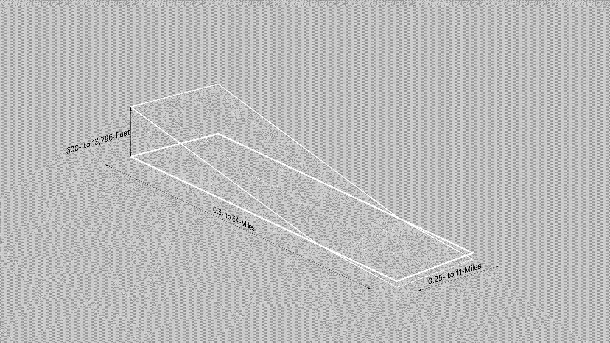
Image: Planetary fractals of ‘āina: ‘ili/ahupua‘a/moku, oceanic, atmosphere, Earth, orbit, moon. ‘Āina can be seen as a fractal, or a pattern that repeats itself at different scales.
Source
The Hawaiian word 'moku', as a verb, means to cut and divide, while as a noun, denotes both an island and a district that organizes the island into tangible land divisions called ahupua‘a. While there are always variations to the rule that correspond with profoundly ecological, political, or phenomenological circumstances, ahupua'a are generally encompassing spaces between the mountains and the sea, including the sky and reef. Moku and ahupua‘a are examples of indigenous built environments that foregrounds a culture of ceremondy and care to safeguard resources like land, water, food, materials, family, and daily life.Hawai‘i-Futures presents an applied theory of ahupua‘a that centers the concept of “ahupua‘a recovery,” a term coined for Hawai‘i-Futures to encapsulate the “process and ecology of reclaiming lost, stolen, erased, corrupted, or destroyed land, water, and other island resources.” This strategic approach to reclaim Āina (that which feeds) emphasizes climate resilience, demilitarization, and social justice as viable strategies to transform the built environment into a source wellbeing. Despite ongoing debates on the contemporary relevance of moku and ahupua‘a concepts, Hawai‘i-Futures asserts their value. Seen through the lens of design thinking and information science, ahupua‘a can be understood as data visualization and navigation tools. Furthermore, the ahupua‘a’s continuing significance is largely due to Hawaiian female scholars’ efforts, framing it as a feminist construct, the survivance of which has become a beacon for revolution, civil and human rights, justice, sustainability, familiy, joy, and love.
Vision
Hawai‘i-Futures summons the habits of mind in which the cycles and surfaces of wai (water) organize the physical and emotional processes that craft city life. It advocates for an ecological revolution—driven by infrastructural adaptations that advance biocultural regeneration and demilitarization—supporting a future where the built environment pulses in harmony with the rhythms of the land, sea, and sky. This aims to secure wellbeing and the enduring vitality of life and culture in the Pacific. In Hawai‘i's future, a revitalized built environment will shepherd global communities towards paths of sustainable and equitable development. A future where seismic shifts towards the recovery of Indigenous systems of sustenance fortify cultural practices, food sovereignty, homebuilding, and land justice.Methodology
Hawai‘i-Futures unites perspectives from diverse fields like art, architecture, infrastructure, and regional planning to stimulate a built environment transformation. The Moku Systems Recovery Framework employs a digital platform of animated cartographies that simulate a holographic comprehension of the built environment, integrating geological, ecological, and biocultural dimensions responsive to the distinctive cultural experience of life on volcanic islands, in Hawai‘i Nei. The dynamic graphics bridges modern planning and traditional ecological wisdom to communicate parameters for recovering ahupua‘a with a moku systems approach.Intent
Hawai‘i-Futures reveres the wisdom of the ahupua‘a, the moku, and the wider Indigenous knowledge systems, advocating for their relevance and compatibility to sculpt a world that is deeply rooted in tradition yet gazes resolutely into the past while moving towards the future. Embarking on this transformative journey together, we initiate the reimagining and reshaping of our relationships with the land, with each other, and with the myriad forms of life that inhabit our shared world. Hawai‘i-Futures transcends speculative exercise; it is a clarion call to action—a call to cultivate a future that is not only just and regenerative but vibrantly teeming with culture and life.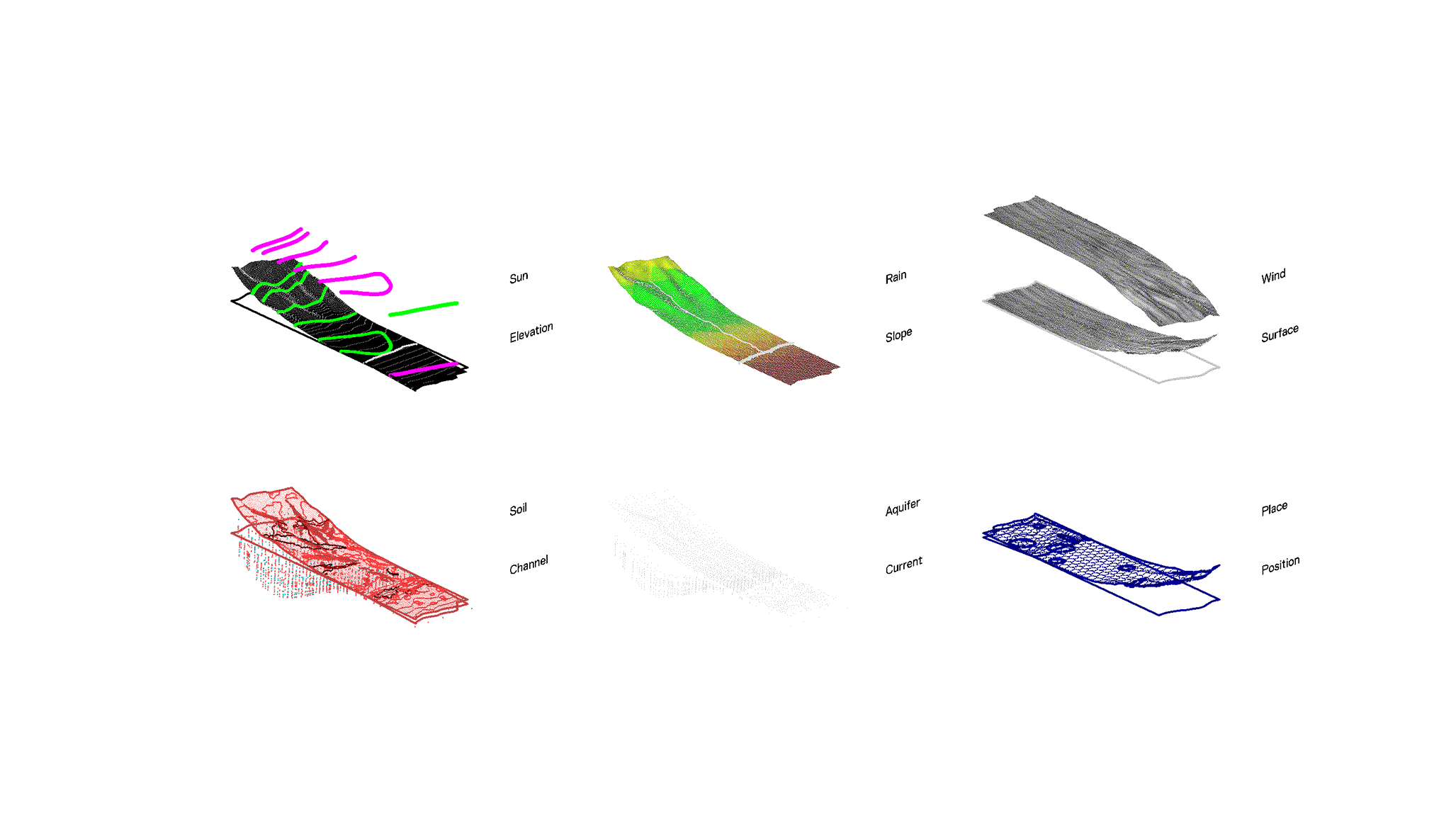
II.
Framework Logic
Moku and Ahupua‘a arise from data that reveal insights into the optimal use of resources for sustenance. The constant interpretation, interpolation, and communication of data into culture and knowledge is a dynamic human process unfolding in real-time. Information, being fluid, evolves and changes as it traverses the channels, currents, and positions of matter and life. On the contrary, Western systems of land-use districts, designed to restrict data processes for maximum economic yield (such as American urban, agricultural, or conservation zoning typologies) must evolve to keep pace with the speed and flux of the resources (like water and its various forms) they aim to regulate.
Moku: Scale & Ecocosm
Critical parameters for ahupua‘a recovery aim to reclaim the historical land division as a contemporary technology of sustenance. This framework follows a logic advocating a sustainable, contemporary built environment reflecting a fractal organization—an indigenous concept deeply rooted in Hawaiian wisdom and cultural practice. This organization is seen in ‘āina, the land, which reveals the fractal nature of space, from the island to district scale—both termed "moku".
The fractal blueprint of 'āina is seen across five projective scales—moku, ahupua‘a, kīpuka, ‘ili, and kauhale—each playing a distinctive role in fostering resilience and ecological consciousness. This organization encapsulates a city as interconnected neighborhoods, advocating sustainable practices, and preservation of natural elements, advancing interconnectedness, balance, and continuity across urban scales.
The ahupua‘a, segments within this fractal cityscape, are vital for urbanism. They integrate indigenous knowledge and biocultural resource management, optimizing resource distribution, and harmonizing human activity with nature. Within the cityscape, kīpuka serve as ecological recovery zones, performing tasks including reforestation and watershed revitalization, facilitating ecosystem balance and recovery.
At the neighborhood scale, ‘ili zones form the blueprint for holistic development, refining local planning for sustainable and socially equitable outcomes. At these neighborhoods' core, kauhale, symbolizing city-blocks, enhance communal productivity, reorienting local economies towards sustainable resource networks, and instilling shared responsibility among inhabitants.
Understanding the fractal nature of 'āina and its implications for urban environments allows us to appreciate different scales and their role in overall management. This fractal perspective illuminates the path towards the recovery and resilience of urban environments.
Organization
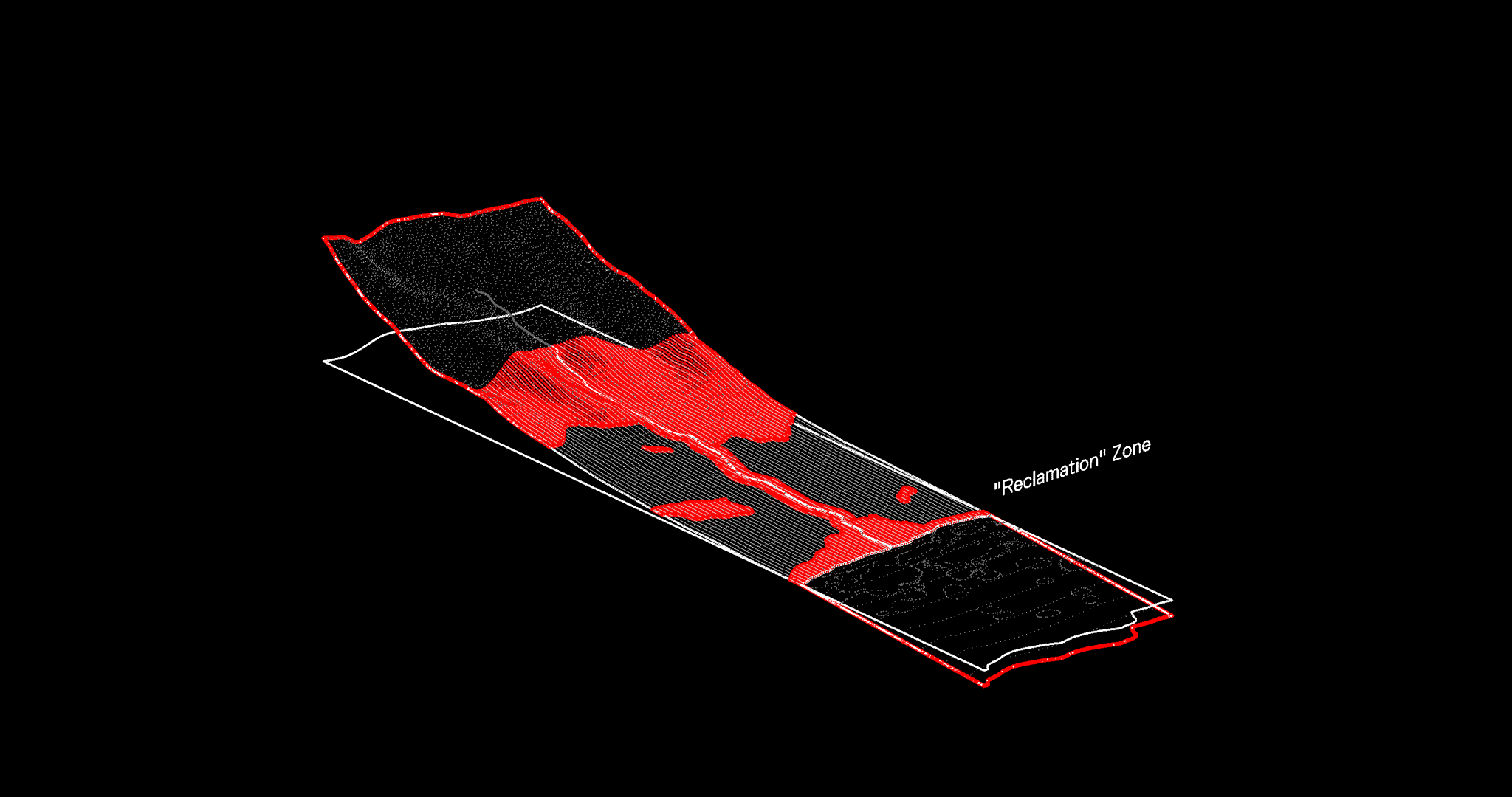
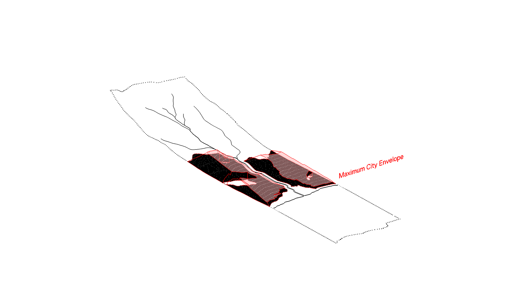
The Moku Systems Framework for Ahupua‘a Recovery is organized into two main sectors that together choreograph the overarching recovery process, each playing a unique but interconnected role to replace the current Euclidean basis of American zoning protocol: Reclamation Districts and Revitalization Districts.RECLAMATION DISTRICTS:
REVITALIZATION DISTRICTS:
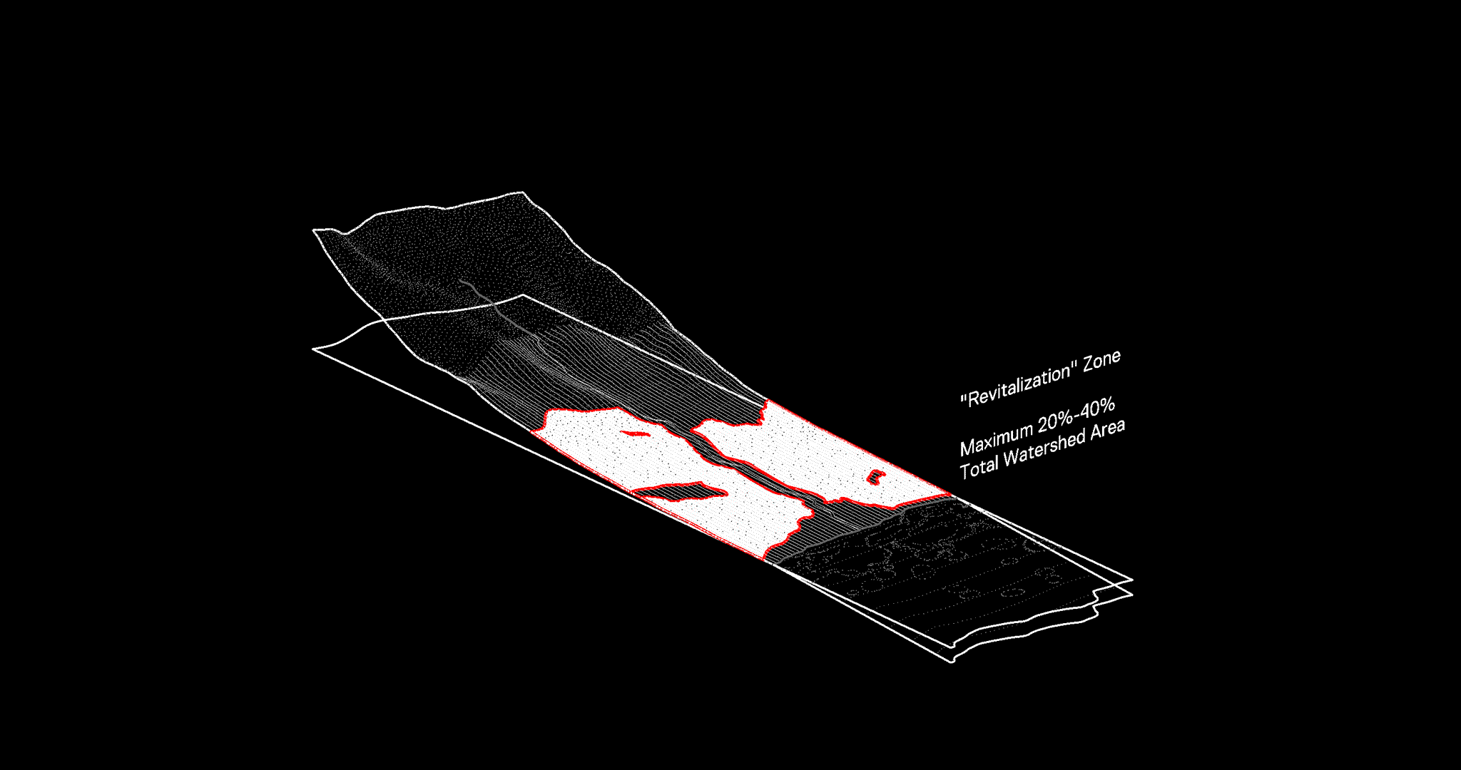
The future demands the challenging yet indispensable task of reclamation—reverting selected urbanized areas to their natural state to respond to sea level rise, beach erosion, and storm surge, or to enhance forests' flood mitigation capabilities. The reclamation process, implemented in areas around channelized streams, filled wetlands, landfills, and dredged reefs, employs a process of subtraction. This may involve changes in zoning or even the total removal of existing structures. Architecturally or culturally significant structures are preserved or relocated, while other developments are deconstructed, their materials repurposed in Revitalization Districts to stimulate the local economy. Conversely, revitalization districts aim to weave high-density living with novel housing typologies, localized food production, markets, and resource generation. The goal is to optimize these areas, ensuring efficient utilization of 20%-40% of the total watershed area for human development while preserving the remainder for ecosystems services and cultural practice.
Feasibility
A spectrum of legal tools already exist to facilitate this transition, such as tax incremental financing, eminent domain, conservation easements, public land trusts, publicly or privately funded acquisition or buyout of properties within these high-risk recovery zones, and even repatriation. While this will necessitate substantial investment, the long-term advantages, like the costs avoided through climate change mitigation and resilience, would compensate for the initial outlay. Moreover, these benefits are perpetual, as the risks are permanently averted once the recovery process is accomplished. A detailed cost analysis is provided in the hawaii Futures rogue studio supplements.Time
The interactions between the two districts are dynamic. Reclamation and revitalization processes collaboratively unfold over several generations (25-100 years), with priorities fluctuating based on factors like costs, community engagement, and environmental catastrophe risk. Together, they rejuvenate the economic and cultural value of ahupua'a as a public resource. The framework advocates a balance between human activity and environmental preservation, safeguarding a sustainable and resilient future for Hawai'i across five projective scales—moku, ahupua‘a, kipuka, ‘ili, and kauhale—each playing a distinctive role in achieving sustainable urbanism rooted in indigenous wisdom and cultural practice:This framework emphasizes a data-based method of drawing boundaries based on physical environmental parameters that also have emotional and cultural relevance. While our focus is on these physical parameters, we recognize the ever-present programmatic and phenomenological parameters that invariably create exceptions, especially when it comes to boundary delineation. The following parameters are identified as a general structural framework for translating entities like moku and ahupua‘a in a contemporary context intending to disrupt that which constrains it—the physical structure of US Urbanism, the agromilitourized built environment, addressing conflicts between real estste development versus the biocultural functionality of a place. A particular emphasis focuses on restoring these areas to their peak productive potential, thereby converting them back into sustainable technologies in their own right.
III.
Recovery Parameters
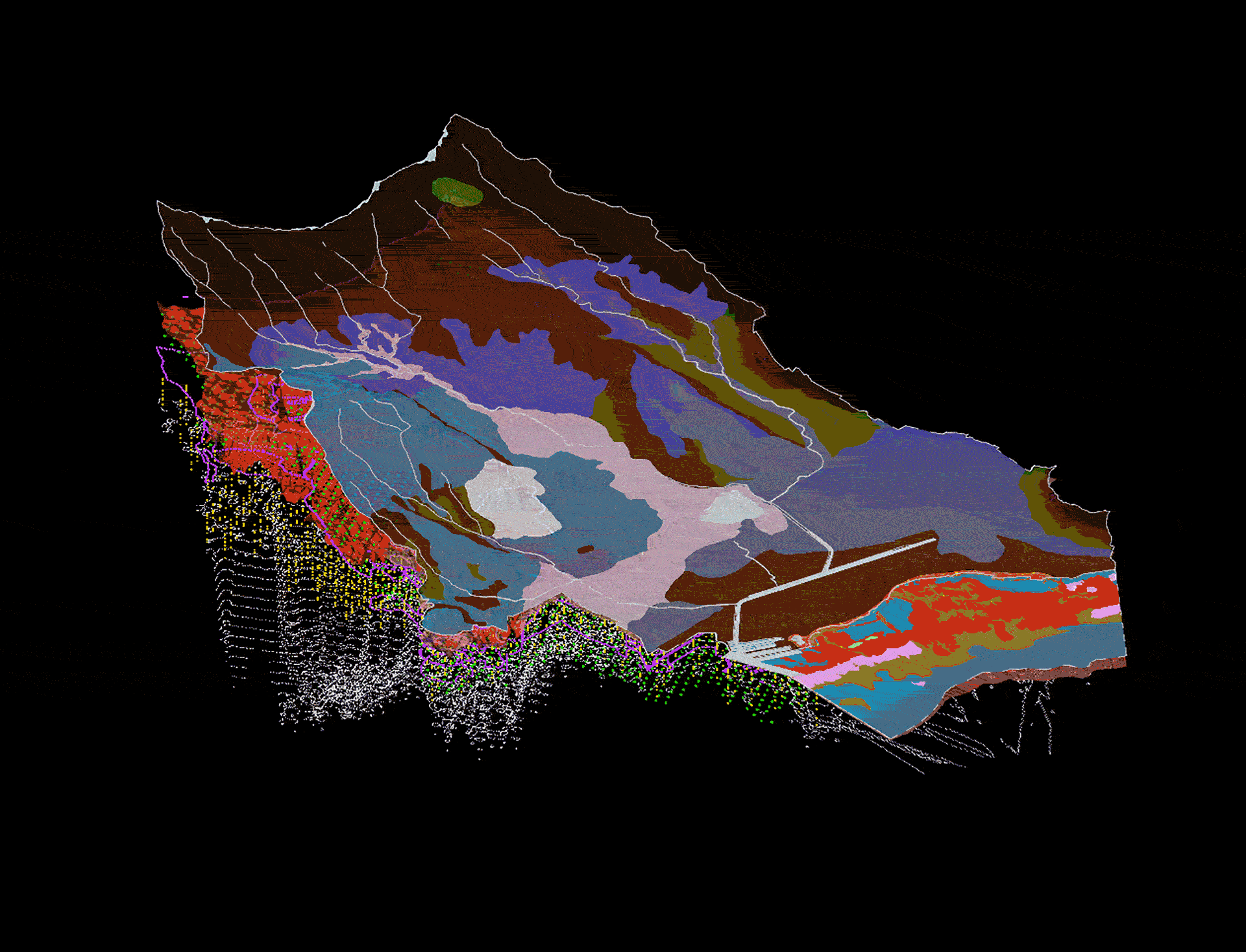
Building on the framework organization, the following parameters of the Moku System Recovery Framework serve to inform the various boundaries that shape the specific extents and functions of each ahupua‘a recovery. These parameters are instrumental in understanding the intricate relationships between the physical environment and cultural practices, helping us to design sustainable and resilient ecosystems. Each parameter, detailed below, outlines a distinct facet of the environment and its cultural significance, serving as a reference point for our recovery efforts. The summary of these parameters are as follows:
Soils, Fields, Open Spaces Foundations for agriculture and biodiversity, these areas are vital for food security and ecological health.
Coastlines, Ocean Buffer zones against sea level rise, they also provide areas for recreation and support a variety of marine life.
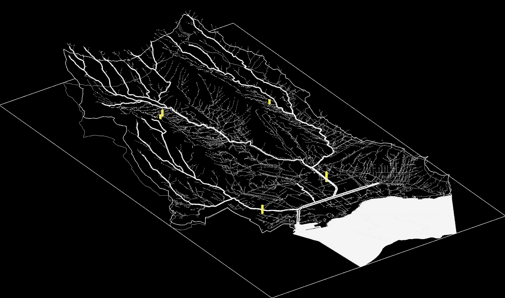
Streams, Gulches
Lifelines of the local ecosystem, providing sustenance and acting as biocultural corridors.
Reefs, Fishponds, Fisheries Vital for local economies and food security, these areas also protect coastlines and host a variety of marine life.
Prime Forest, Mountain, Aquifer Sources of freshwater, Crucial carbon sinks, habitats for diverse species, and sources of timber and non-timber products.
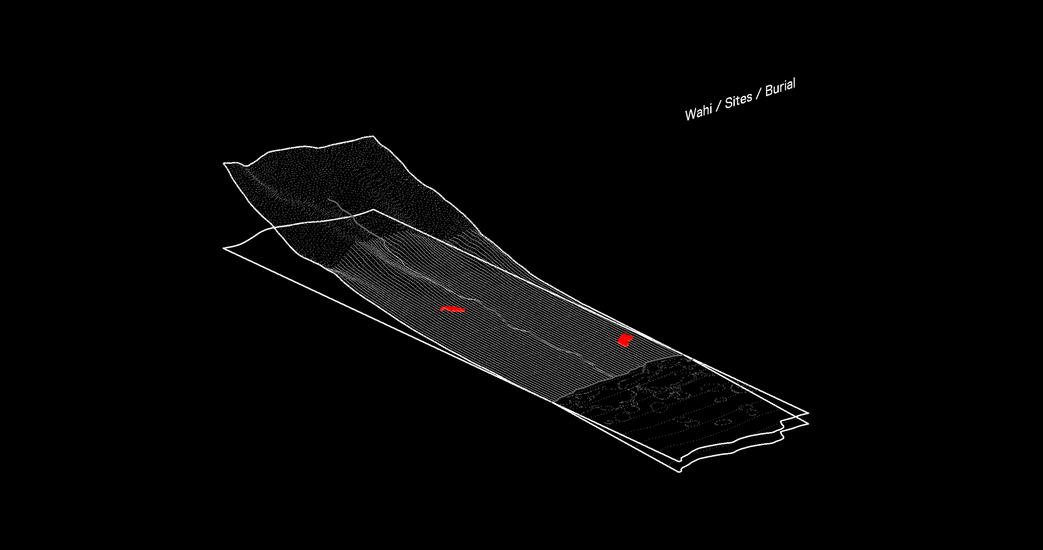
Sites, Placenames, Phenomenon Cultural and spiritual hubs that link the present generation with their ancestors and their traditions.
Wetland, Flooding Natural filtration systems and flood control mechanisms, these zones also host unique biota.
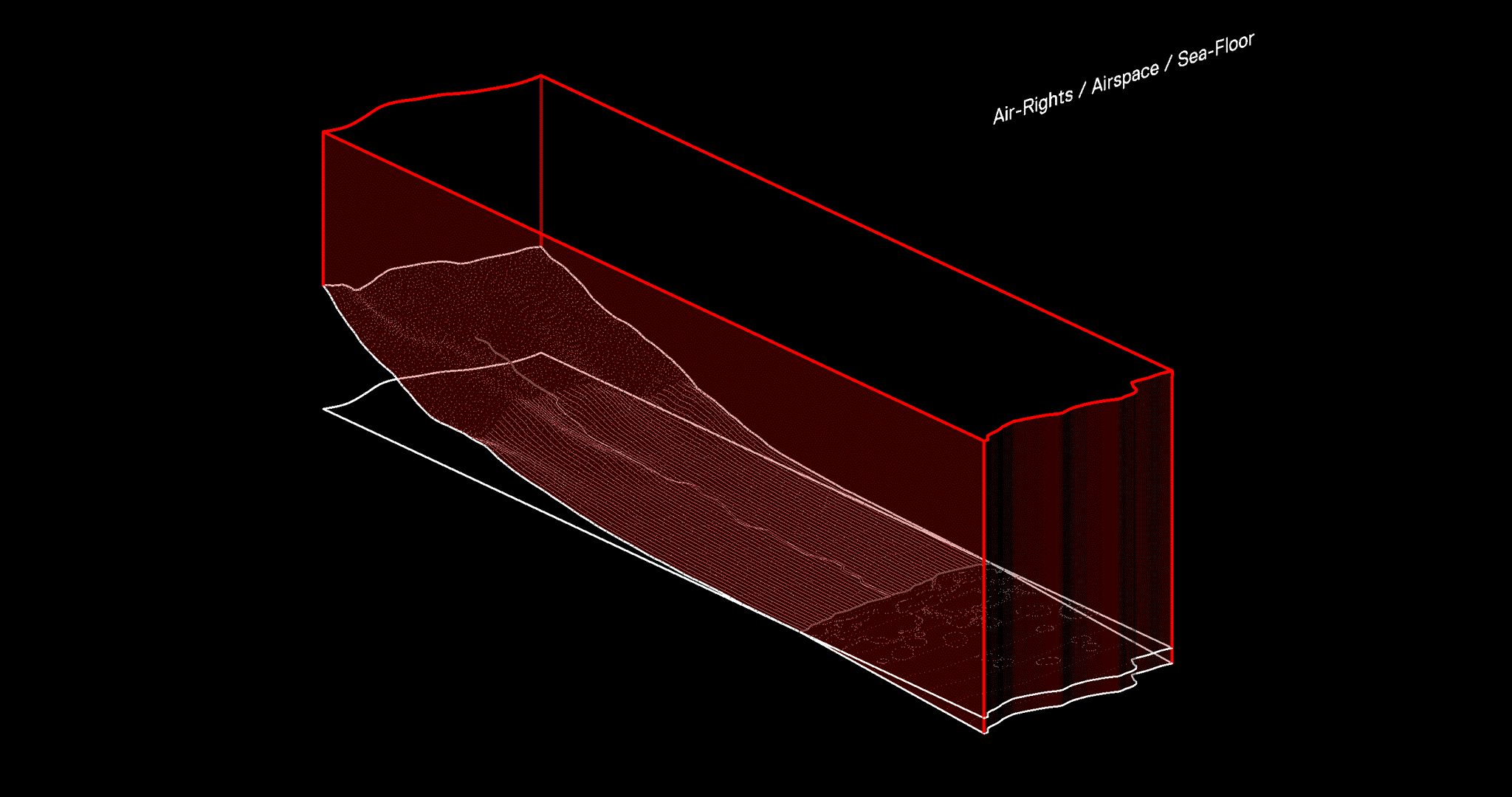
Airspace, High-Seas, And Seafloor Often overlooked, these areas play crucial roles in transportation, communication, and ecological processes.

Guiding Principles
The Moku Systems Recovery Framework establishes strategic principles to guide sustainable and resilient transformations in Hawai'i's land use zoning. These ten principles are not mere ideas; they represent a focus for actionable regional interventions, crucial to the recovery of ahupua‘a and the establishment of a moku systems-based built environment.
Geospatial Intellect and Response
Geopolitical boundaries align with individual ecosystems to form Ahupua‘a Management Districts. This enhances land and energy management, recognizing all conservation zones to sustainably manage ecosystems, respecting the inherent wisdom and cultivation of the land.
Data, Mapping, Speculation
Dynamic data illuminates optimal resource utilization in ahupua'a, transforming raw information into culturally accessible knowledge. This iterative process reconfigures traditional land-use systems to adapt to evolving resource availability.
Biocultural Ecozoning
Place-based ecological and resource potential zones replace static functional zoning. This approach optimizes water use, respects land characteristics, and incorporates indigenous knowledge of site-specific attributes.
No-Build Districts & Regenerative Forestry
Designated no-build zones preserve vital natural areas, promoting ecosystem regeneration. Community activism safeguards these zones, managing waste and sustainability.
Regenerative Building Networks
Buildable zones consider energy efficiency, pedestrian access to natural resources, and carbon footprint reduction. This strategy curbs urban sprawl, decreases automobile dependence, and integrates ecological resources into developed areas.
Built (Circular Economies) Environments
Within 'ili cooperative networks, circular economies flourish in the buildable zones of each ahupua‘a, optimizing material use, energy efficiency, localized food production, market distribution, and community participation.
Schools, Food Security , Mutual Aid
Hydroponics and other advanced food production technologies become commonplace, woven into homes, markets, and schools, enhancing land justice and food security. Elementary schools become community gardens and farmers markets, instilling respect for indigenous knowledge and nurturing future land stewards.
From Infrastructure to Ecotechnology
Utility infrastructure transforms into an ecotechnology, integrating renewable energy, water resources, waste reuse and recycling, food production, education, and cooperative markets, with a perspective that infrastructure and landscape are one biophysical biocultural entity.
Density, Dispersal, Typological Transformations
Housing typologies adapt to accommodate population growth and integrate hydroponic food resources, reducing the carbon footprint, optimizing material use, and fostering a relationship between home, food, and community resources.
Land Justice and Resilient Affordable Capacity
Modular building systems facilitate affordable housing, integrate agricultural resources, increase population capacity, and return areas within "no-build" zones back to the environment. This approach mirrors a respect for the land.
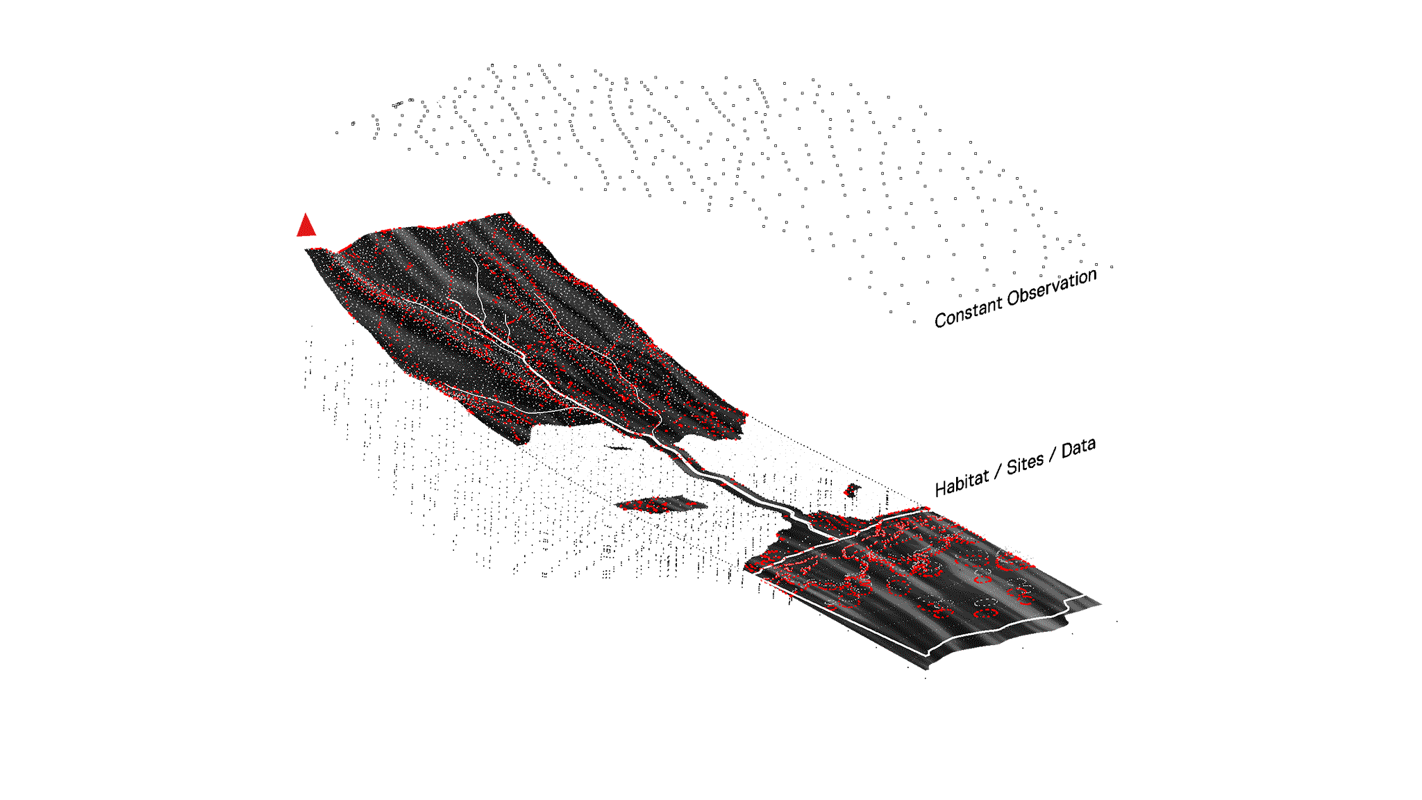
Ceremony, Ritual, & Observation
These practices foster human connection with nature, expressing respect and gratitude towards the environment and promoting an understanding of natural cycles.
Direct Action, Protectors, Public Testimony
Activism evolves into a stewardship ethos, rooted in respect and understanding of the land. Protectors serve as guardians of the land and its narratives, their actions standing as a testament to their commitment to preserve the ecological and cultural integrity of Hawai'i.
IV.
Paramater Outcomes
Moving beyond theoretical recovery parameters, this section focuses on the tangible implementation of the Moku Systems Recovery Framework. Here, we examine the practical implications of our strategic approaches within the Hawaiian landscape. These outcomes, guided by our framework, represent foundational elements for a future that combines indigenous wisdom and innovative methodologies. They aim for a future where human activity aligns with and respects natural processes.
Interactive Multifunctional Land Use
The framework transcends conventional urban and rural taxonomies, advocating for a synergy between ecological hydrological cycles and anthropogenic development, thereby fostering long-term sustainability and watershed productivity.
AffordancesThis element revolves around the reinvigoration of anthropological connections with ecosystems, thereby enabling judicious harvesting of energy, water, and other resources in the context of mitigating climate change impacts.
Access
Here, the concentration is on fabricating expansive biotopes, superseding the traditional concept of 'parks.' The premise enables continuous movement between oceanic and mountainous zones, thereby facilitating profound interaction with diverse ecologies.
AcademiesThis domain utilizes the environment as an animate laboratory, engaging a spectrum of learners, educators, and practitioners in an educative process that amalgamates indigenous wisdom with modern environmental sciences.
Adapt & Adjust
This aspect underscores resilience in the face of natural or economic calamities. Strategies such as the restoration of riparian vegetation serve to attenuate flood impacts and coastal storm surges.
AlimentaryIn the spirit of sustainability, this approach rejuvenates traditional agrarian technologies, ensuring reliable sustenance sources that help preserve cultural practices and propagate values across generations.
'Ili, Nodes, & Networks
The proposed paradigm suggests pedestrian-centric communities linked by shared resources such as food hubs, educational institutions, local enterprises, and public transportation infrastructure, thereby fostering a vibrant, interconnected socio-economic matrix.
Biocultural AdjacenciesThis element underscores strategic urban planning that synchronizes population density and architectural elevation with the accessibility of natural features like streams, forests, and agricultural fields, reinforcing the biophilic connection of urban inhabitants.
Solar Envelopes
The calibrated management of sun angles, as per the solar envelope concept, serves to efficiently distribute sunlight, implement strategic shading for community areas, and guide the selection of suitable flora based on specific ecological conditions.
The calibrated management of sun angles, as per the solar envelope concept, serves to efficiently distribute sunlight, implement strategic shading for community areas, and guide the selection of suitable flora based on specific ecological conditions.
Data, Information, Resource Potential Zones
The approach evolves beyond conventional Euclidian zoning, integrating environmental data into the formation of performance-based zoning ordinances at the municipal level, thereby ensuring that urban infrastructures are harmoniously intertwined with their natural surroundings.
The approach evolves beyond conventional Euclidian zoning, integrating environmental data into the formation of performance-based zoning ordinances at the municipal level, thereby ensuring that urban infrastructures are harmoniously intertwined with their natural surroundings.

RECOVERY PARAMETERS
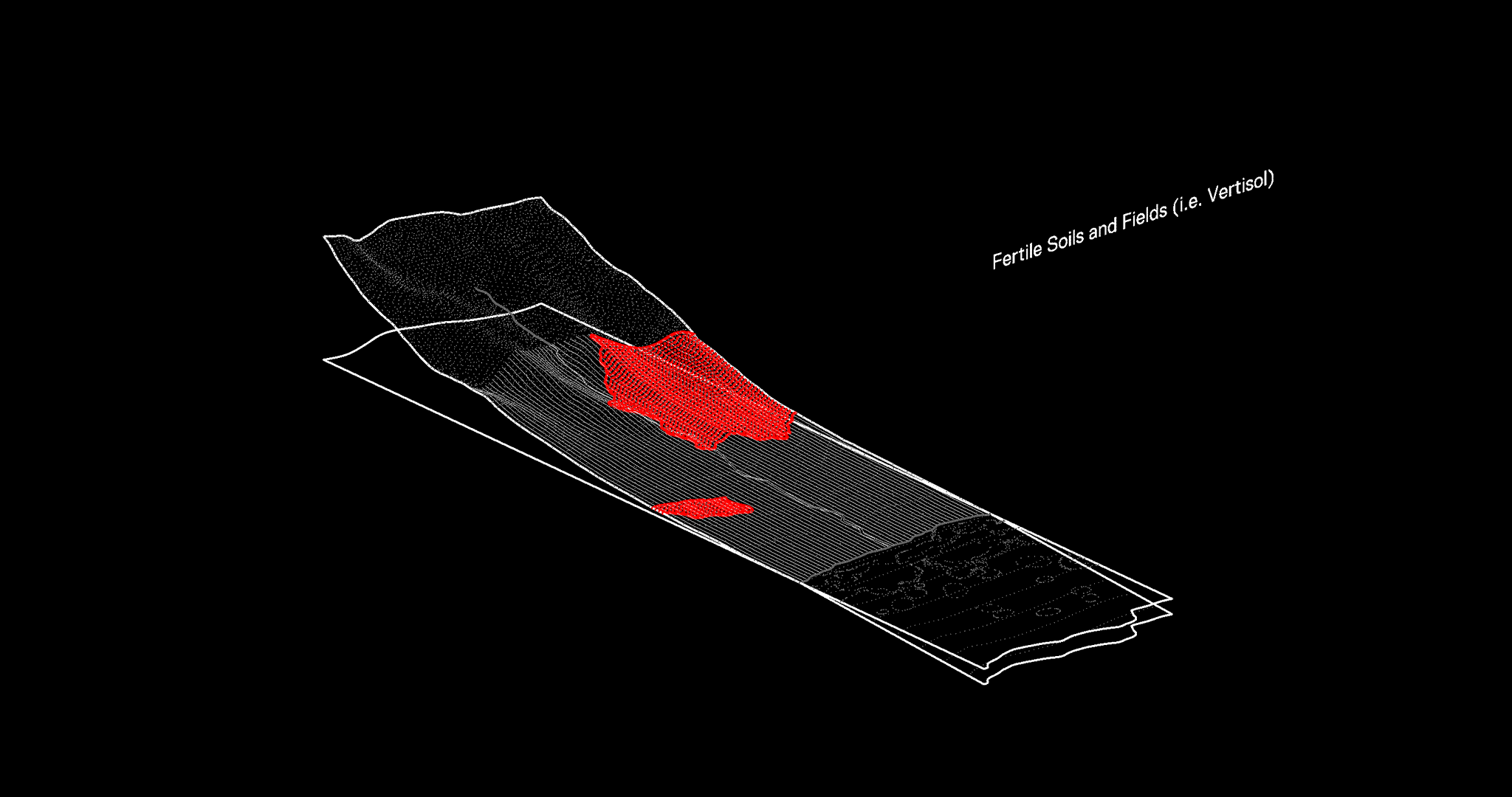
SOILS, FIELDS, OPEN SPACES
These include all the soil types, like mollisols, aridisols, inceptisols, and vertisols, the active clay soils that undergo drastic expansion and contraction during wet and dry seasons. These open spaces, prime for agricultural use, are strategic zones for groundwater absorption and food production, to start the conversation.
Image Prompts: Imagine a community engrossed in the joy of harvest, their shared laughter echoing across the vast, fertile fields, under the golden afternoon sun. Imagine the same community, their brows furrowed in determination, tending to the rich soil in the early morning mist, their hands bearing the mark of their dedication to the land.
RECOVERY PARAMETERS
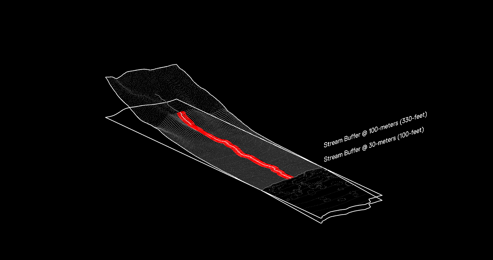
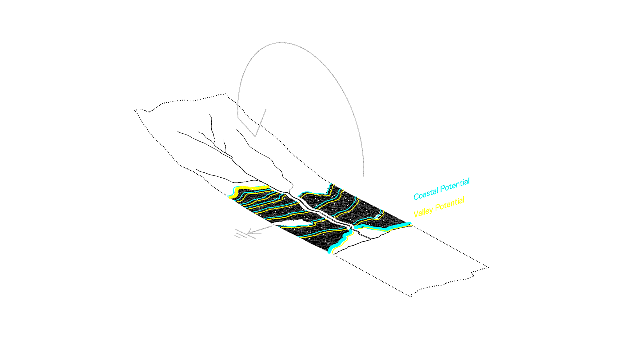
STREAMS, GULCHES
Two priority setbacks are defined for these aqueous corridors: a 30-meter zone immediately adjacent to the stream edge, and a secondary 100-meter buffer. These regions prioritize not-to-low density building cover over large development, mitigating flood risk, enhancing riparian ecosystems, and supporting bioculture.
Imagine a group of children playing by the side of a clear, bubbling stream, their joyful shouts merging with the song of the water and the rustle of leaves. Imagine community members working tirelessly to clear debris from the stream, their efforts a testament to their commitment to preserve the water's clarity and vitality.
RECOVERY PARAMETERS
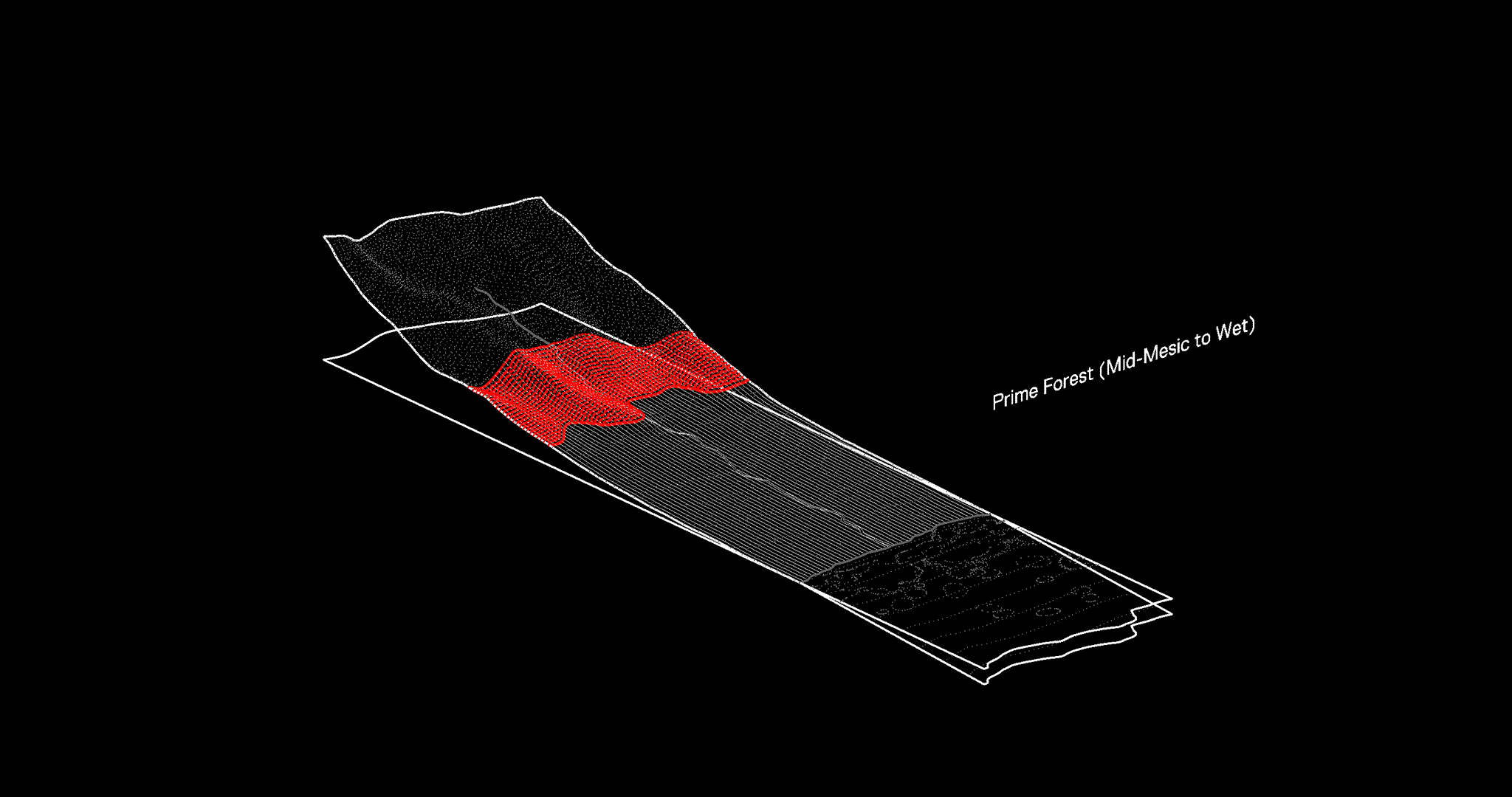
PRIME FOREST, MOUNTAIN, AQUIFER
Prime forest parameters are determined by elevation and solar orientation. These areas, particularly wet forests as low as 200 meters and mesic forests that may be sea-level, should remain undeveloped to preserve critical freshwater resources.
PRIME FOREST, MOUNTAIN, AQUIFER
Prime forest parameters are determined by elevation and solar orientation. These areas, particularly wet forests as low as 200 meters and mesic forests that may be sea-level, should remain undeveloped to preserve critical freshwater resources.
Imagine a community celebration at the peak of a lush mountain, their shared stories and songs carried by the wind through the verdant forest. Imagine the solemn journey of community members, their path illuminated by the first light of dawn, as they labor uphill, carrying saplings for reforestation.
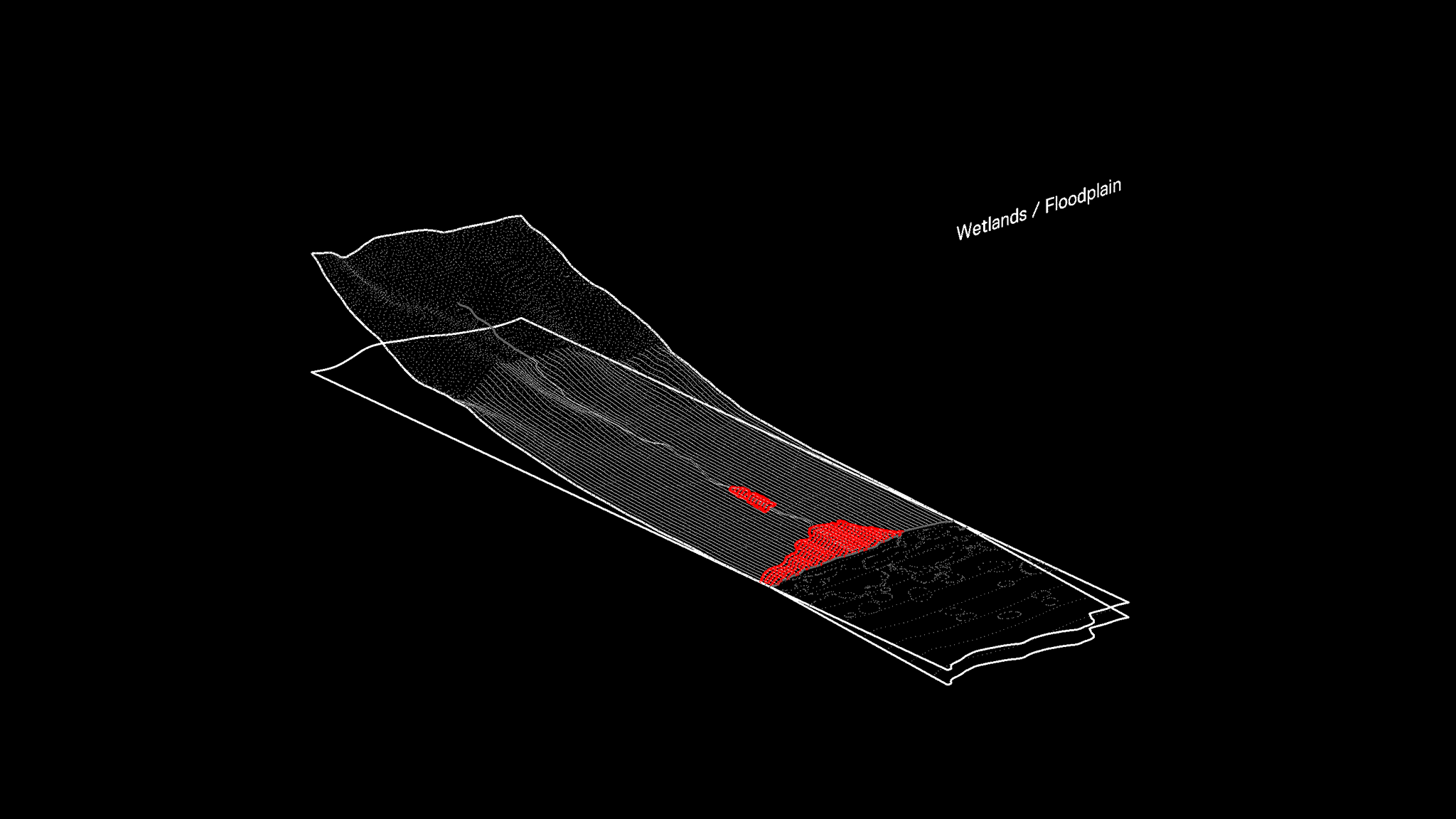
RECOVERY PARAMETERS
WETLAND, FLOODING
These zones, with varying water saturation and salinity levels, are critical for ecosystem restoration, carbon sequestration, and groundwater recharge. They include both coastal and upland habitats, even those currently dredged or filled.
WETLAND, FLOODING
These zones, with varying water saturation and salinity levels, are critical for ecosystem restoration, carbon sequestration, and groundwater recharge. They include both coastal and upland habitats, even those currently dredged or filled.
Imagine a group observing the dance of local birds over the wetlands, their shared silence a tribute to the mesmerizing display of nature. Imagine community members waist-deep in water, their faces mirroring determination as they work to restore the wetlands, their hands gently replanting native species.
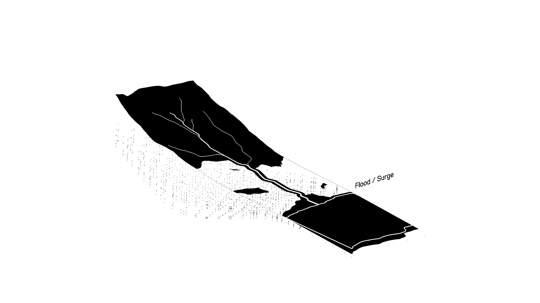
RECOVERY PARAMETERS
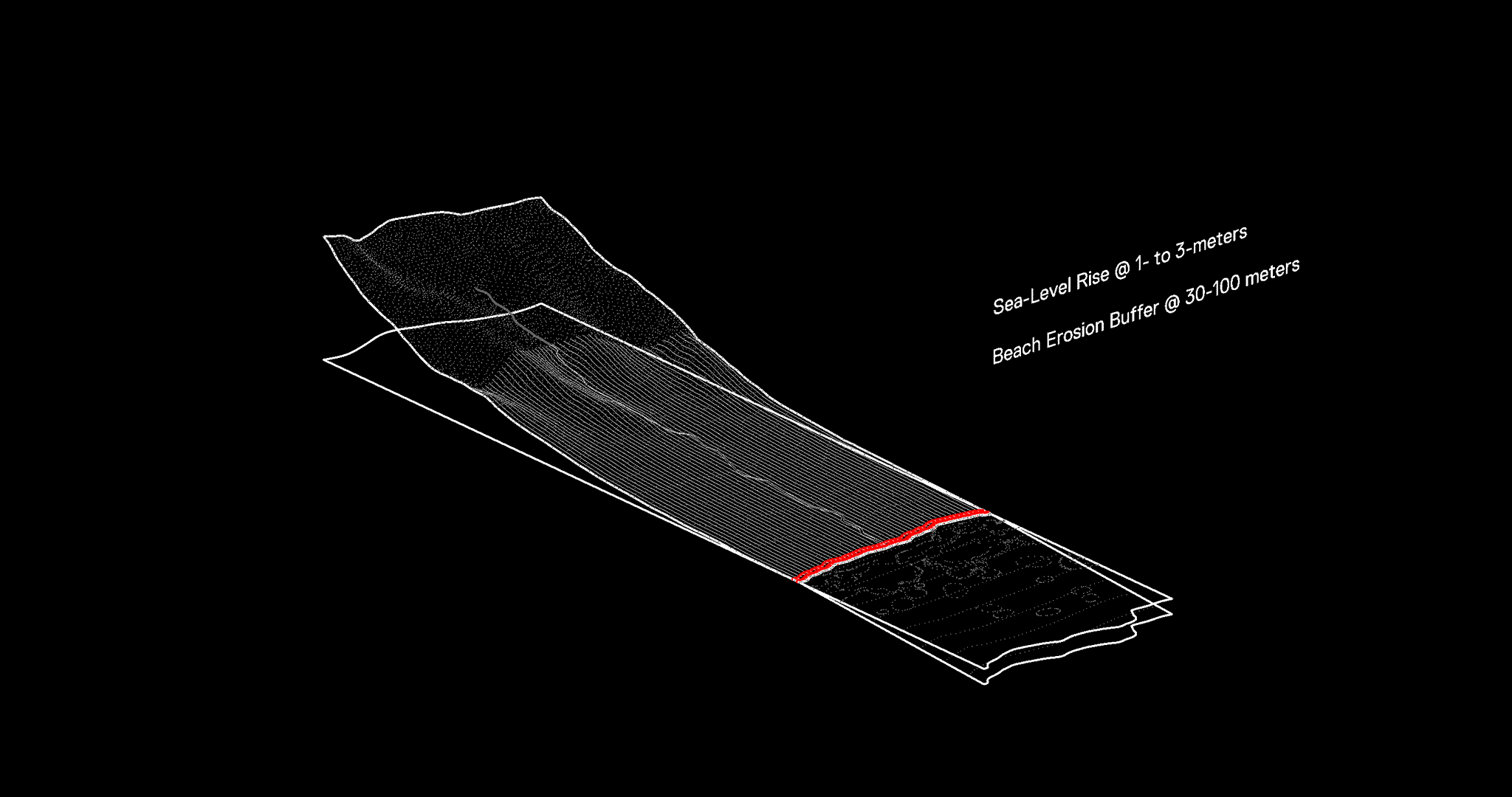
The coastline parameters account for beach erosion and storm surge protection within a 100-meter zone from the highest wave wash. Projections of sea-level rise, varying with topography and expected to be between 1-to-3 meters, also shape these boundaries.
COASTLINES, OCEAN
The coastline parameters account for beach erosion and storm surge protection within a 100-meter zone from the highest wave wash. Projections of sea-level rise, varying with topography and expected to be between 1-to-3 meters, also shape these boundaries.
Imagine a community gathering at the coastline during sunset, their shared stories and laughter blending with the rhythmic sounds of the ocean. Imagine the same community in the early hours, their efforts focused on cleaning the beach, their hands picking up remnants of human activity washed ashore.
RECOVERY PARAMETRICS
INTERACTIVE LAND-USES
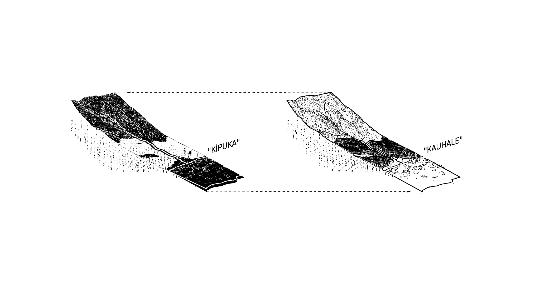
The concepts of Kīpuka and Kauhale advance beyond contemporary notions of urban and rural areas. These interactive land-use categories emphasize the harmony between ecological cycles and human development. Interaction between zones occurs across various intensities depending on the relationships between people and their environs, aiming to manage the long-term growth of a developed footprint without hindering watershed health and productivity.
INTERACTIVE LAND-USES
The concepts of Kīpuka and Kauhale advance beyond contemporary notions of urban and rural areas. These interactive land-use categories emphasize the harmony between ecological cycles and human development. Interaction between zones occurs across various intensities depending on the relationships between people and their environs, aiming to manage the long-term growth of a developed footprint without hindering watershed health and productivity.
Image Prompts: Imagine a vibrant community living in harmony with the land, their dwellings interspersed with lush fields and vibrant streams, a testament to the balance between human activity and nature's bounty. Imagine that same community engaged in thoughtful discussion, their hands gesturing over a shared map, their faces reflecting the weight of responsibility for managing their shared home without compromising its health and productivity.
RECOVERY PARAMETRICS
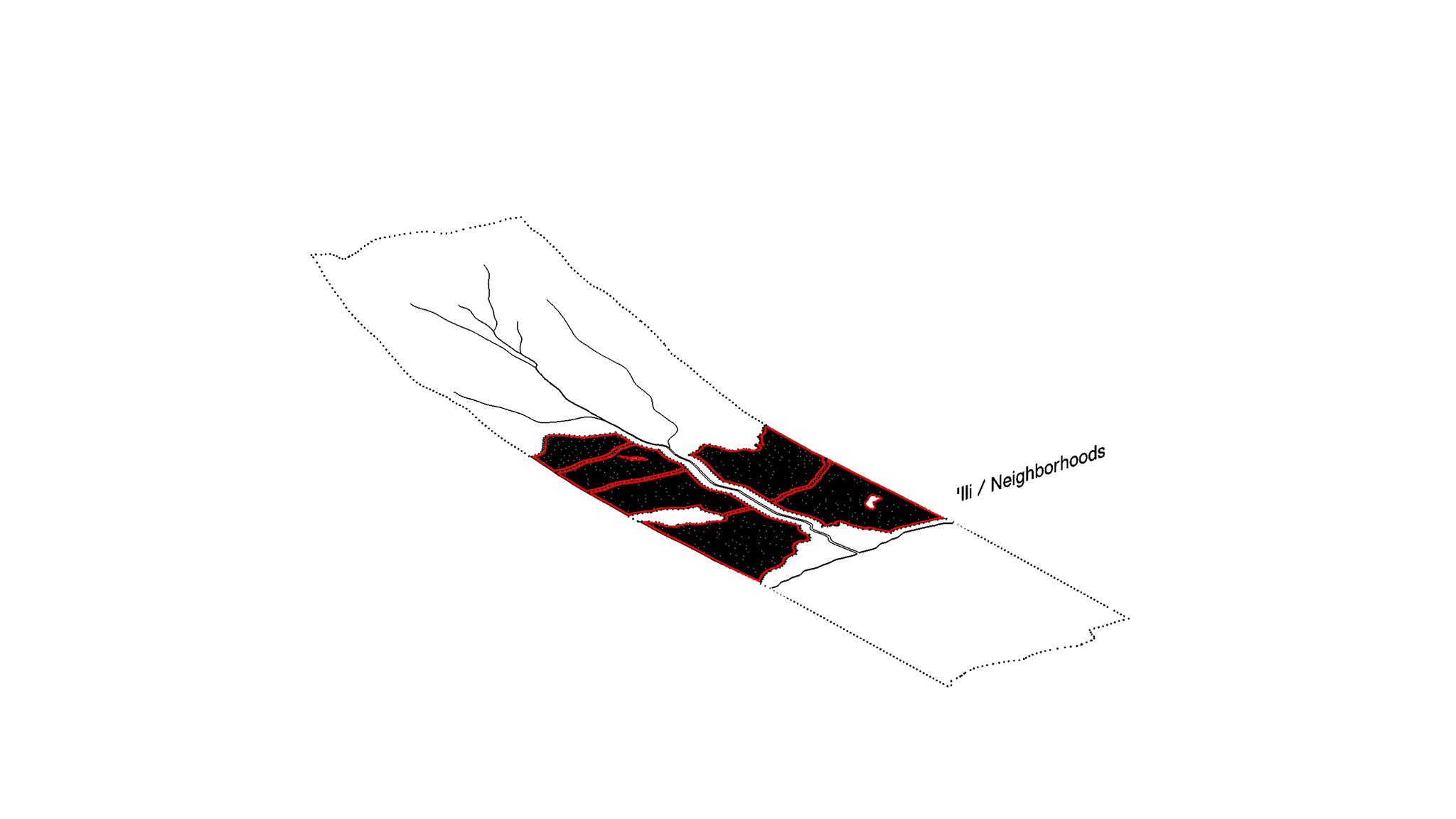
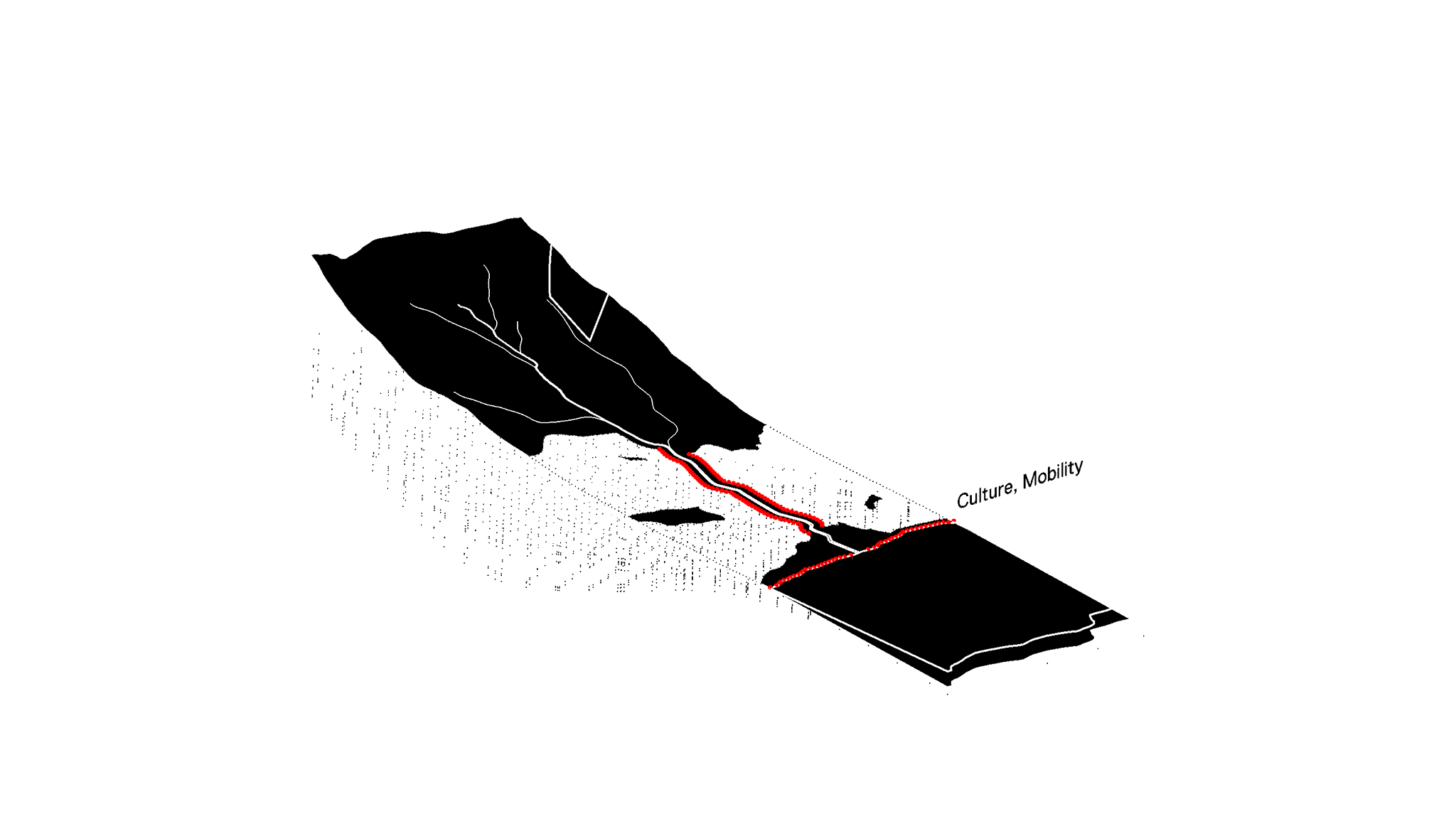
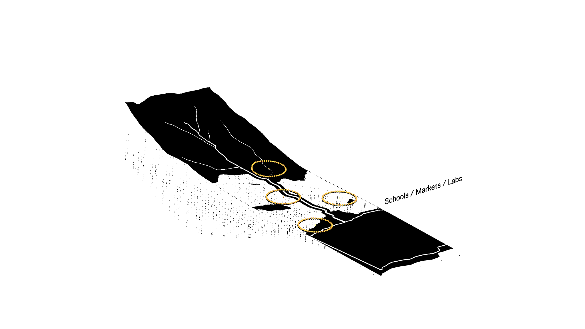
'ILI, NODES, NETWORK
The kauhale system proposes a network of neighborhoods, organized around pedestrian access to resources like food hubs, regenerative resource infrastructure, schools, local businesses, and public transportation. These resources may include Food Hubs and Farmers Markets; Regenerative Resource Infrastructure; Schools and Galleries; Local Artists Collectives, Businesses, and Services; Public and Alternative Transportation.
Image Prompts: Imagine a bird's eye view of a kauhale system, a network of neighborhoods knitted together by pedestrian paths leading to resources like food hubs, schools, and public transportation. Now, imagine the people of these neighborhoods, their hands busy in the creation and maintenance of these resources, their faces marked by the determination and satisfaction of building a vibrant, interconnected community.
RECOVERY PARAMETRICS
AFFORDANCE
Affordance is a function of Kīpuka to recover human relationships with the habitats, sites, and data resources that comprise an ahupua'a. These relationships afford the ability for humans to harvest energy, water, and other resources while managing the pace of change in climate.
AFFORDANCE
Affordance is a function of Kīpuka to recover human relationships with the habitats, sites, and data resources that comprise an ahupua'a. These relationships afford the ability for humans to harvest energy, water, and other resources while managing the pace of change in climate.
Image Prompts: Imagine a community standing together on the edge of a Kīpuka, their eyes reflecting the intricate relationships between the habitats, sites, and resources that define their ahupua'a. Imagine the same community, their sleeves rolled up, harnessing energy and water from their environment, their actions demonstrating their commitment to manage the pace of climate change.
RECOVERY PARAMETRICS
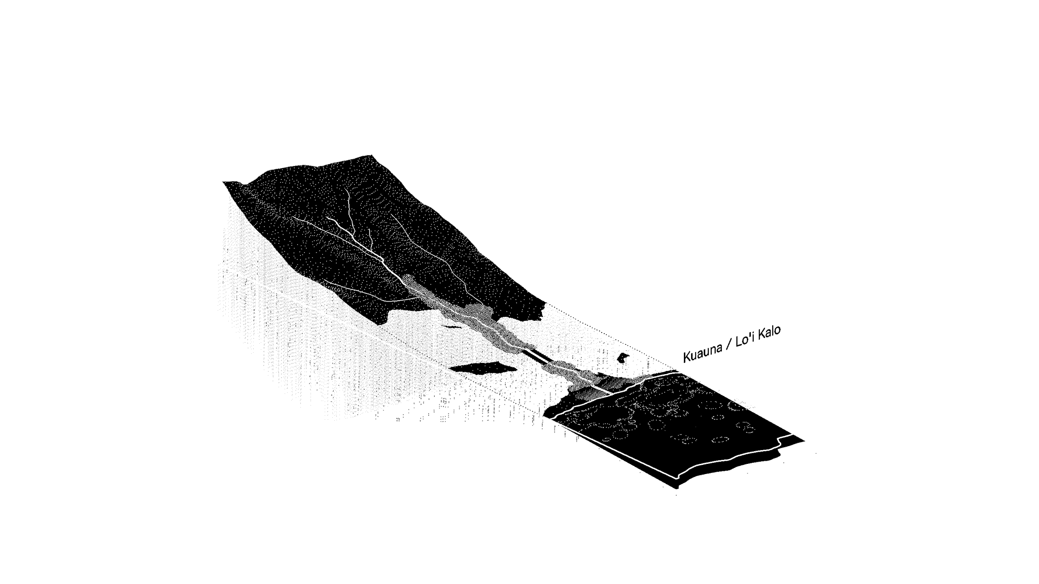
ALIMENTARY
Alimentary, like the tube in which food passes through the body, describes the function of kīpuka to nourish. The architecture of traditional farming technologies like kuauna (pondfields), kuapā (fishponds), and kua'iwi (fields) transform kīpuka into reliable food sources that perpetuate cultural practices and values for generations.
Image Prompts: Imagine a community gathered around a bountiful harvest, their shared satisfaction stemming from the knowledge that their traditional farming techniques have nurtured both the land and their bodies. Imagine this same community hard at work in the fields, their bodies bent in labor, their faces showing the strain but also the determination to uphold practices that sustain their culture and their land.
RECOVERY PARAMETRICS
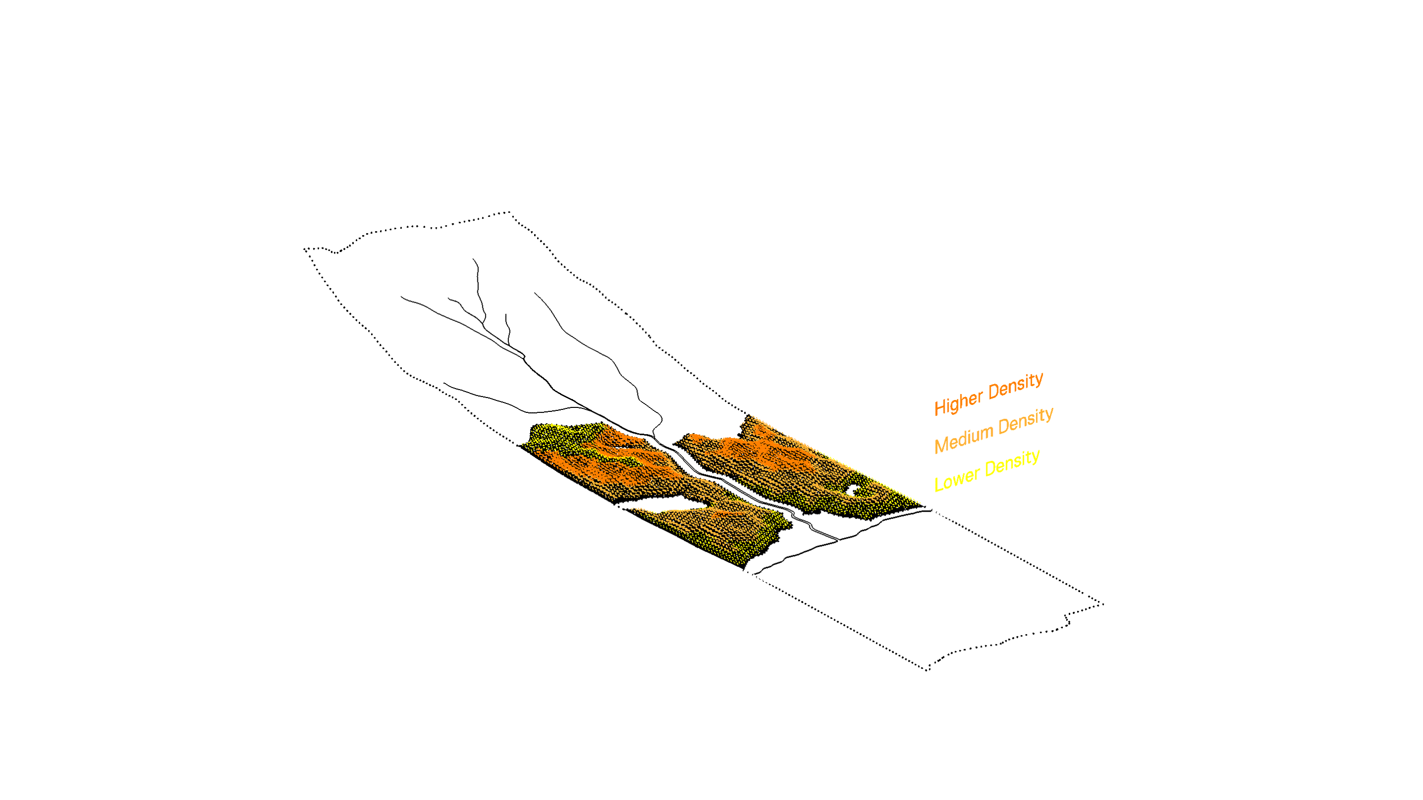
Population density and building heights are set according to walking distances to streams, shorelines, forests, wetlands, fields, and other important parameters that define the kīpuka district. These adjacencies reestablish the island's ecosystems as the primary organizing element of the form of the kauhale as city to reinforce the perceptual connection of people to their mauka-makai milieu.
BIOCULTURAL ADJACENCIES
Population density and building heights are set according to walking distances to streams, shorelines, forests, wetlands, fields, and other important parameters that define the kīpuka district. These adjacencies reestablish the island's ecosystems as the primary organizing element of the form of the kauhale as city to reinforce the perceptual connection of people to their mauka-makai milieu.
Image Prompts: Imagine a community where the population density and building heights are determined by walking distances to streams, shorelines, forests, and fields, its design reinforcing the people's connection to their natural surroundings. Now, imagine the people of this community, their hands and minds engaged in the complex task of shaping their city in a way that respects and enhances its ecological adjacencies, their shared goal a sustainable future where nature and urban life exist in harmony.